
IHNC: 8-25-26
August 25, 2026
U.S. Army Corps of Engineers, New Orleans District
7400 Leake Avenue
New Orleans, LA 70118
Re: Public Comment on the Final General Reevaluation Report and Integrated Supplemental Environmental Impact Statement for the Inner Harbor Navigation Canal (IHNC) Lock Replacement Project
Dear Corps of Engineers:
On behalf of Louisiana Landmarks Society, please accept the following comments on the Final General Reevaluation Report and Integrated Supplemental Environmental Impact Statement (“Final GRR/SEIS”) for the Inner Harbor Navigation Canal Lock Replacement Project. We appreciate the opportunity to submit comment and the comment deadline extension.
Our review mostly compared the Final GRR/SEIS (July 2026) against the Supplemental Draft GRR/SEIS the Corps circulated only fourteen months earlier (May 2025). That comparison shows a project whose economic justification weakened over the intervening year as its cost grew, and whose remaining risks continue to fall disproportionately on the historic communities surrounding the IHNC.
For the reasons below, Louisiana Landmarks Society urges the Corps to withhold further action on the recommended plan until it has more fully addressed: (I) the project's declining and increasingly fragile economic justification; (II) unresolved floodwall, bridge, and contamination risks, including unsecured funding for the St. Claude Avenue Bridge; (III) the disproportionate allocation of cost and risk to the surrounding communities relative to the project's benefits; (IV) the incomplete evaluation of the Violet alternative, which does not reflect the Louisiana International Terminal now under development at that site; and (V) the substantial risk of renewed litigation given the project's history of two prior federal injunctions.
I. In the Year Between the Draft and Final Reports, the Economic Justification Moved in the Wrong Direction
Rather than resolving the uncertainties USACE itself flagged in the Draft, the Final GRR/SEIS shows a project that has become both more expensive and less economically justified in the span of a single year:
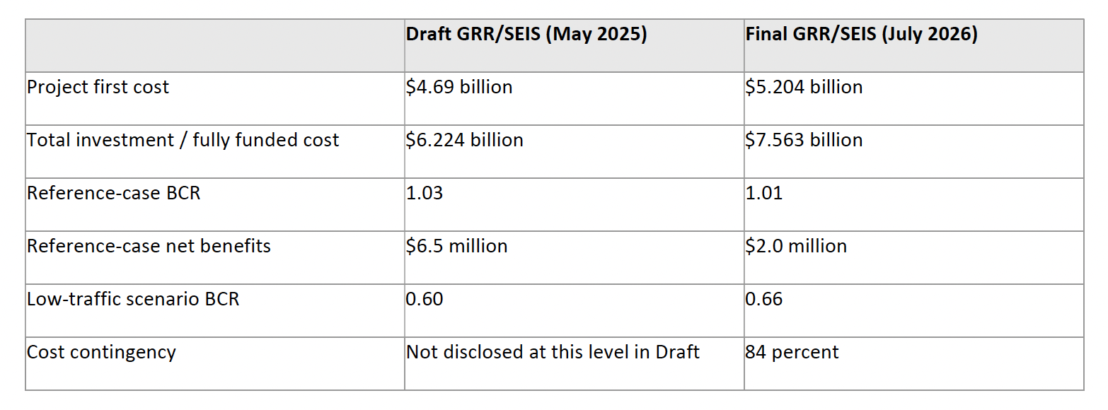
The project's first cost rose approximately 11 percent in one year, from $4.69 billion to $5.204 billion, while total investment cost rose from $6.224 billion to $7.563 billion. Over that same period, the Benefit-Cost Ratio (BCR) fell from 1.03 to 1.01 (with the low-traffic scenario at 0.66) and net benefits collapsed by nearly 70 percent, from $6.5 million to just $2.0 million — a razorthin margin for a multi-billion-dollar federal investment.
This is not simply a one-year dip: the Corps’ own reported BCR for this project has been trending sharply weaker through successive studies. The January 2017 draft GRR/SEIS reported a benefit-cost ratio of 4.78:1 for the recommended plan; by the May 2025 Supplemental Draft, the Corps’ updated analysis of that same plan had fallen to 1.03:1; and the Final GRR/SEIS now reports 1.01:1. A project whose officially reported economic justification has fallen from nearly 5-to-1 to barely above breakeven across three successive Corps studies warrants far more scrutiny.
A project already this close to the 1.0 threshold has essentially no room to absorb further cost growth, and the Final GRR/SEIS confirms that further growth should be expected: the design has still not reached the 35 percent maturity threshold that USACE's own Engineer Regulation 1110-2-1302 (April 2026) requires at this stage, and the Corps has attached an 84 percent cost contingency, signaling major uncertainty in design, geotechnical conditions, hydraulic modeling, utility conflicts, remediation, and construction risk. The Final GRR/SEIS also acknowledges that the project's current estimated cost already exceeds the statutory cost ceiling under Section 902 of WRDA 1986, and that USACE anticipates seeking a higher congressional authorization once the design reaches 35 percent maturity. In other words, the BCR reported today is a snapshot taken before the design work most likely to move the cost — and therefore the ratio — has even been completed.
The reference-case benefits used to calculate this ratio also warrant scrutiny. Figure 3-4 of the Final GRR/SEIS, captioned "Traffic Demand Forecasts: 2017 GRR," displays reference, high-growth, and low-growth commodity tonnage projections extending to 2080 that carry forward the project's 2017 forecast; a footnote directs readers to Appendix D for "updated results," but Figure 3-4 itself was not replaced or corrected in place. On that chart, the reference case projects roughly 21 million tons transiting the IHNC by 2025, and even the low-growth case projects roughly 19 million tons.
An updated forecast does appear later in the report, in Figure 4-12 ("Traffic Demand Forecasts: 2017 GRR and 2025 GRR Project Demand Tonnage," Chapter 4, p. 120), which plots the original 2016-vintage forecast lines against new 2025-updated lines. Even the updated 2025 reference-case line in Figure 4-12 shows roughly 17–18 million tons at 2025 — still well above actual reported tonnage.
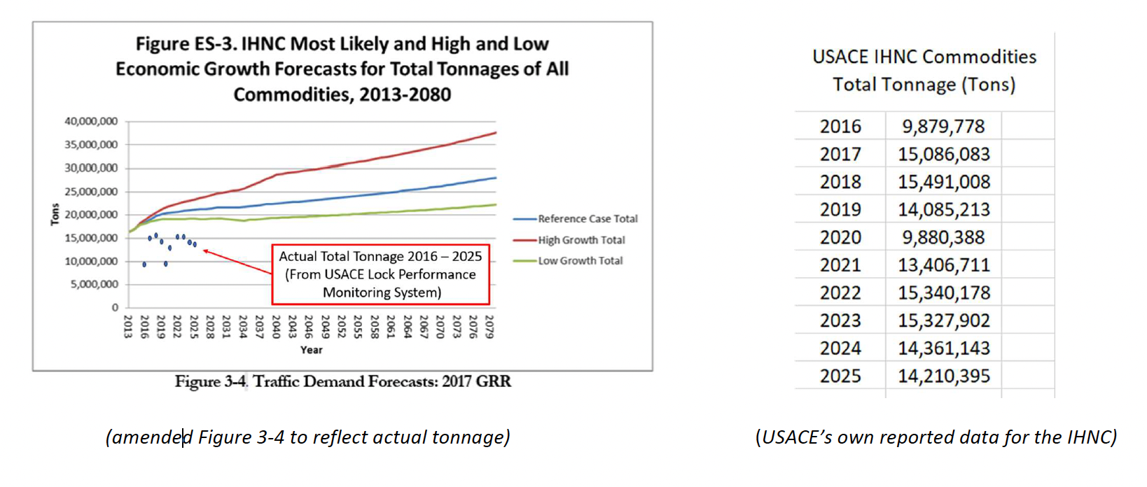
Actual 2025 tonnage of 14,210 falls roughly 32% below the ~21 million tons projected in Figure 3-4's reference case, roughly 25% below its ~19 million ton low-growth case, and materially below even the "updated" 17–18 million ton reference case shown in Figure 4-12. Tonnage has not exceeded 15,491 million tons in any year since 2016, and has trended flat-to-declining since 2018 — a pattern the reference-case forecast underlying the reported project benefits does not appear to reflect.
If the forecast underlying the reported benefits has been overstating actual tonnage — across both the original Figure 3-4 forecast and the "updated" Figure 4-12 forecast — then the benefits, and the 1.01 BCR calculated from them, warrant reexamination independent of the cost growth discussed above. Louisiana Landmarks Society asks the Corps to publish a full reconciliation of both the 2017 and 2025 reference-case forecasts against actual reported tonnage for 2016–2025. (Actual tonnage data: USACE IHNC Commodities report, via https://ndc.ops.usace.army.mil/ords/r/lpms/corps-locks/monthly-tonnagereport.)
The Final GRR/SEIS also invokes "national security" to justify the project beyond its 1.01 BCR, calling the lock a "critical valve" for Gulf Coast refining and citing its role in moving military fuels and equipment. That framing seems to be overstated. The Recommended Plan is a shallow-draft lock limited to -22 feet, far short of the -36-foot deep-draft designs evaluated in 1997 and 2009, and deep-draft access into the IHNC was physically foreclosed in 2009 when the MR-GO was sealed. Notably, two of the principal drivers behind the original project — the Port of New Orleans as non-Federal sponsor and a deep-draft navigation mission — are both now absent: the Port withdrew its cost-share support and its sponsorship in 2012, and the project itself shifted to a shallow-draft design shortly thereafter, undercutting much of the original impetus for proceeding. While the IHNC Lock plays a role within a barge network that carries strategically relevant cargo like petroleum and chemical products, the report does not present project-specific evidence — such as defense logistics data — to substantiate its characterization of the lock replacement as an "urgent national security priority." A shallow-draft facility on a waterway no longer connected to deepdraft shipping cannot double as indispensable deep-draft security infrastructure.
II. The Final GRR/SEIS Leaves Critical Floodwall, Bridge, and Contamination Risks Unresolved
The Final GRR/SEIS discloses, but does not resolve, at least three significant risks to the flood protection system and the recommended plan's core infrastructure.
First, Section 4.5.1 acknowledges that hydrocarbon contamination — including several polycyclic aromatic hydrocarbons — remains beneath approximately 900 feet of existing LPV floodwall adjacent to the former U.S. Coast Guard site, and that this section of floodwall would need to be removed to tie the realigned MR&T floodwall into the new lock. Rather than presenting a remediation plan, the report describes only a site-investigation work plan coordinated with the Louisiana Department of Environmental Quality, Remediation Division (LADEQ-RD) since 2019, and states that an actual Corrective Action Plan would be prepared only if, during future design, USACE determines there is no practicable way to avoid disturbing the affected section.
No Corrective Action Plan, remediation cost estimate, or approval schedule appears in the Final GRR/SEIS or its appendices. Given that removal of this floodwall segment is integral to the recommended plan's construction sequence, Louisiana Landmarks Society asks the Corps to disclose, prior to any final decision, whether disturbance of this contaminated section can in fact be avoided, and if not, to provide the Corrective Action Plan, its estimated cost, and its schedule for LADEQ-RD approval.
Second, Chapter 4 describes construction of a cofferdam along the eastern wall of the IHNC — with sheet piling driven to elevation -90 feet and a temporary bypass channel dredged to -17 feet immediately adjacent to it — as the first construction feature of the project, using barge-mounted vibratory and impact hammers over a multi-year construction sequence. The Final GRR/SEIS's discussion of pile-driving vibration and noise addresses impacts to nearby residents and structures, but we could not locate any discussion of the geotechnical precautions, monitoring protocols, or contingency plans intended to protect the structural integrity of the existing eastern IHNC floodwall itself during this dredging and pile-driving activity. Louisiana Landmarks Society asks the Corps to disclose what geotechnical monitoring, vibration thresholds, and contingency measures will govern cofferdam and bypass-channel construction adjacent to the existing floodwall, and to confirm that this analysis has been reviewed by a licensed structural or geotechnical engineer independent of the project design team (i.e., Rogers, et.al. 2008;. Geologic Conditions Underlying the 2005 17th Canal Levee Failure in New Orleans; Journal of Geotechnical & Geoenvironmental Engineering).
Third, the Final GRR/SEIS itself acknowledges that “residual risks remain, particularly for the St. Claude Avenue Bridge,” even after accounting for the project's 84 percent cost contingency, and states that USACE will continue “exploring alternative delivery approaches and funding sources” for the bridge replacement, including the possibility that non-federal entities assume some of its costs. In other words, funding for a structure the project cannot proceed without — the bridge that must be demolished and rebuilt to allow lock construction, and that provides the primary vehicle connection between the Lower Ninth Ward and the rest of the city — is not yet secured. The report states these costs will remain classified as navigation costs “unless and until viable alternatives with committed partners are secured,” but does not address what happens to the project schedule, or to the neighborhoods depending on that bridge, if such partners are not found. Any misstep, delay, or funding shortfall affecting the bridge component carries the potential to extend construction impacts and community inconvenience well beyond the fourteen-year schedule the Final GRR/SEIS presents. Louisiana Landmarks Society asks the Corps to disclose the status of bridge funding negotiations, the contingency plan and estimated schedule impact if a funding partner is not identified before
construction begins, and how residents would be kept informed of any resulting delays.
III. The Recommended Plan's Mitigation Framework Is Incomplete and Insufficient to Offset Its Costs and Risks to Surrounding Communities
The GRR/SEIS separates several categories of construction-related risk from the project's core economic justification. The report's own accounting distinguishes "NED costs" from "non-NED" implementation-risk costs (regulatory, labor, and contract acquisition risk baked into an 84% cost contingency), and acknowledges that if those non-NED costs were excluded, the BCR would be "demonstrably higher" than the official 1.01. Separately, CIMP and TMP costs are folded into the Benefit-Cost Ratio not through independent economic analysis, but through an assumed one-to-one benefit-to-cost ratio — meaning their social and community costs are effectively cancelled out on paper without being verified against the actual value delivered. The St. Claude Avenue Bridge replacement is credited differently, receiving a benefit offset based on the extension of its service life rather than independent valuation of its community function. Remediation of contamination at the former Coast Guard site is even less resolved: while costs tied to floodwall realignment are committed to the project, the report states that cost-sharing responsibility with the site's prior owners for any broader remediation "would need to be developed" — leaving that portion an open liability rather than a cost priced into the project.
Over an optimistically proposed fourteen-year construction period from 2033 to 2047, residents of the Lower Ninth Ward, Bywater, St. Claude, and St. Bernard Parish will be subject to continuous pile driving, excavation, and dredging; nighttime lighting and noise; heavy truck traffic; and prolonged detours as the St. Claude Avenue Bridge is disassembled and rebuilt — severing a critical connection between the Lower Ninth Ward and the rest of the city while the Traffic Mitigation Program remains conceptual. The shift from float-in-place to cast-in-place lock construction will add further vibration, dust, and diesel emissions in neighborhoods that already bear a disproportionate share of the region's environmental burdens; notably, the 2009 SEIS recommended a float-in-place design specifically because it caused less construction-related community impact than a cast-inplace plan. The project also runs through four historic neighborhoods, three of which are National Register Historic Districts.
While the AMOA establishes a specifically defined $20 million Historic Preservation Fund (Stipulation II.E) with fixed allocation tiers for the Holy Cross and Bywater NRHDs, the AMOA itself acknowledges that the CIMP "does not have spatially defined actions at this time" and could trigger additional Section 106 review — meaning the CIMP's lack of specificity creates a live mechanism, via Stipulation VI.C, for CIMP-driven historic-property impacts to draw further into that same $20 million fund, which was sized and tiered for the AMOA's own already-known impacts rather than for open-ended additions from an unfinalized CIMP.
The Final GRR/SEIS is quick to quantify the project's economic benefits — including projected local construction job creation and regional economic output — but does not apply the same rigor to quantifying the losses the surrounding community will bear, whether economic losses to businesses, property value, desirability, or in quality of life. While we appreciate the increase in the CIMP to $170 million, we still find the plan lacking in specifics. None of this disruption is offset by a proportional share of the project's benefits, which are navigational and commercial in nature.
IV. The Violet Alternative Was Evaluated in Isolation and Does Not Reflect Current Conditions
The Final GRR/SEIS states that USACE reconsidered a lock site at Violet, took what it describes as a hard look, and determined that a new lock there would result in “substantial and unavoidable wetland impacts” – instead choosing the site most socially disruptive. That determination, however, was reached by evaluating dated information for lock feasibility alone, without regard to the Louisiana International Terminal (LIT) — a Corps-involved deep-draft container port development now under construction in Violet. No USACE study has evaluated the Violet lock alternative together with the Louisiana International Terminal, and the reconsideration accordingly does not include terminal plans, port development, freight corridor changes, changes in scope of freight, economic synergies, or community impacts related to the terminal.
This is a significant analytical gap for anyone assessing Violet's true feasibility today: years-old site evaluation confined to wetland impacts on an otherwise undeveloped parcel does not capture how a Corps-involved terminal already under construction there would change the economic, infrastructure, and community calculus of locating a lock there.
This gap is significant because the rejection of Violet is precisely what directs this project's heaviest construction and social impacts into the Lower Ninth Ward and Bywater. Continuing to evaluate the Violet site as an undeveloped wetland site, without accounting for a Corps-involved terminal now moving forward there, does not reflect current conditions and calls into question whether the alternatives analysis satisfies the requirement to consider a reasonable range of alternatives based on accurate, uptodate information.
V. The Project Carries Substantial Risk of Renewed Litigation
The Final GRR/SEIS's own project history confirms this project has been enjoined by federal courts twice. In 2006, the U.S. District Court for the Eastern District of Louisiana enjoined USACE for failing to take a "hard look" at environmental impacts, including dredging and disposal of the canal's contaminated sediment. In 2011, the same Court vacated the 2009 Supplemental EIS and enjoined USACE again, finding it failed to sufficiently consider how the MR-GO closure's elimination of deep-draft access affected the lock's design and dredging/disposal alternatives.
The same categories of issue remain live. Sediment contamination and disposal are again at issue, now at the former Coast Guard site (Section II). The project's design basis has shifted — from the deep-draft plan considered in 2009 to the shallow-draft plan now recommended — raising the same category of question that triggered the 2011 injunction: whether the current design has been adequately reconciled with the underlying changed circumstances. The organizations behind both prior challenges remain active, and the community distrust the report itself acknowledges suggests they would have standing and cause to challenge these determinations.
Conclusion
Taken together, these concerns — a benefit-cost ratio that has trended sharply weaker across three successive Corps studies as costs rose, resting on a stale traffic forecast and a national security rationale weakened with the shallow-draft plan itself; unresolved floodwall contamination, structural integrity, and St. Claude Avenue Bridge funding risks; a cost-risk allocation that burdens surrounding communities far more than it benefits them; an outdated alternatives analysis at Violet; and a substantial risk of renewed litigation given two prior federal injunctions — raise serious doubts about whether the recommended plan is ready to proceed. Louisiana Landmarks Society respectfully requests a written response addressing each concern above, including independent structural and geotechnical review of the cofferdam and floodwall sequence.
Thank you for your consideration of these comments. Louisiana Landmarks Society looks forward to the Corps' written response.
Respectfully submitted,
Sandra L. Stokes
James R. Logan, IV